Clicking on the linked bridge names will take you to Bridgehunter.com with historical information, location maps and photos. Again, the google map and link to our tour is here. My picasaweb/google photo albums (linked at the left of this page) have many additional photos of the bridges and our trip.
 After spending two truly gorgeous days in Brookings at Harris Beach we decided it was time to move on north and inland. Even though the temperatures were chilly, the sun shone for us at just the right moments to walk the beach several times a day and go see what was in bloom in Azalea Park. On Friday, however, when we packed up to leave, the rain was coming down in earnest. In fact, no matter where we looked on the weather map in Oregon, it was raining. With Lane County having the most concentrated collection of covered bridges on our map, we decided to cross the coast mountains via Highway 126 from Florence to Eugene.
 There are 4 bridges in the western part of Lane County (actually there are five, but we decided that 20 miles of back road to the Fisher Bridge at the very northern border could wait for another day). Our night destination was the ever ready Valley River Mall in Eugene, no hookups and no reservations needed. Just a free space to be for two days in a good location for some bridge hunting. There was no rush to arrive so we could take our time ambling along the back roads finding the bridges.
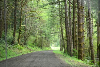 First on our list was the Deadwood Bridge, northeast of Mapleton and Swisshome along the Suislaw River. For the first time, (but not the last on this trip), we remarked about how unlikely it would be for us to travel this back road for any other reason, especially on a rainy gray day. We have been past Mapleton many times, always turning east on 126 and never going north on Highway 36 along the river. The Suislaw was full and beautiful during this time of year, and the river valley was green and dripping wet.
 We stopped in Deadwood at a closed local store to park the MoHo and unhook since we had no idea what condition the road might be in for the additional miles on Deadwood Loop to the bridge. It is always a bit of a surprise when you round the corner for the first view of any of these bridges. They seem so naturally settled into the environment around them, and so sturdy and graceful. We saw Howe Trusses for the first time, unaware that we would grow to really love the words “Howe Truss” by the end of our bridge travels. Wikipedia has a great description of the Howe Truss, a rather amazing piece of engineering that is more prevalent in the west because we still had access to huge timbers during the early part of this century when most of these bridges were built. Another striking feature of this bridge is the slanting floor, made so to ease driving around the curve where the bridge is built.
 We enjoyed Deadwood and then programmed in the coordinates for the next bridge, located on Nelson Mountain Road, not too far away. Even with good maps, there is no way to really know what condition the road might be in. Often there is a sign that says “One Lane Bridge Ahead” but just as often there are no warnings of clearances and no clue if there is anyplace to turn around. For this reason, we tried to explore the back bridge roads with the Tracker whenever possible. At least we could usually turn around or drive through the bridge if needed.
 Nelson Creek bridge was more open than Deadwood, and quite lovely in its rural pastoral setting. If you look closely at the photos of each bridge, you will notice that the portals are just a bit different. We really didn’t notice this until we had seen several bridges and were reviewing the pictures. Somewhere along the way, we read that often the portals were changed and enlarged in later restorations to make room for the larger loads traveling through the bridges.
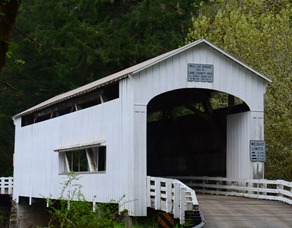 We traveled back to Deadwood to pick up the MoHo once again, and then back to Mapleton and the main highway to Eugene. East of Mapleton, where the Suislaw River crosses the highway, is the Wildcat Bridge. You can see it from the road, but there isn’t much of a pull off, and we had no idea how narrow the road was that curved back under the highway bridge down to the river.
 Mo decided to be safe and parked the MoHo off the road while I walked down to the bridge for photos. It was a good plan! The road is short, steep, and narrow, and the underpass of the highway is very low, with no place to turn around at the bridge. Once again, I found an A. L Striker bridge, the superintendent of bridge building in Lane County during this time period. As well, there was another subtle difference in the portal shape, as this bridge was used for years as a passage for logging trucks over the river.
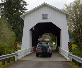 Just a bit west of Eugene was another spot on the map to explore. The Coyote Creek covered bridge is south of Veneta, location of the infamous Oregon Country Fair. The road to Coyote Creek is called Territorial Highway, a name that triggered all sorts of wondering as to its origin. Along the way were some lovely pastoral farms and forests and again, the road leading to the bridge was short and narrow and steeply curved. Once again we parked up on the main road and unhooked the Tracker to go find the bridge and once again it was a good idea.
 The Coyote Creek bridge was in good repair, with some new siding and some old, and again, there was a subtle difference in the portal openings and in the slant of the sidewalls over the creek. At some bridges there are signs with an explanation of the history and renovations and at others there isn’t even a nameplate.
By the time we reached the mall it was early evening and we were ready to kick back and relax with a glass of wine and some supper. Even before we parked, the security person met us with the paper to fill out for our free two night stay and directions to park in a different area this time since the spring games were coming up the next day and shuttles would be plying the parking lot to the University of Oregon.
Clicking on the linked bridge names will take you to Bridgehunter.com with historical information, location maps and photos. Again, the google map and link to our tour is here. My picasaweb/google photo albums (linked at the left of this page) have many additional photos of the bridges and our trip.


![Covered Bridge RV Trip on Google Maps_thumb[3]](https://blogger.googleusercontent.com/img/b/R29vZ2xl/AVvXsEjmwCLj8f3KkCM9dykTi2KsHSOSUNDkBrbTI2ENLrlUp7QjEQmAawdhRClzp_c_mt-IMXNyPe0Y1njv4QOr-KwXbdkZB8OtPvwGjk7W-dn9slAl56N7_9FJEBF2BrvD-6P51z-bkItRMko/s1600-h/Covered%252520Bridge%252520RV%252520Trip%252520on%252520Google%252520Maps_thumb%25255B3%25255D%25255B2%25255D.jpg "Covered Bridge RV Trip on Google Maps_thumb[3]")


 Nan
Nan


